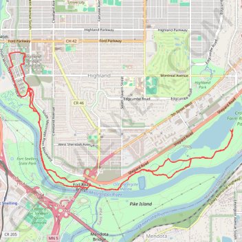
Crosby Farm-Hidden Falls Ride
Loop bike / hike via Old Watergate Marina, Mississippi River, Hidden Falls, Hidden Falls Creek, Upper Lake and Crosby Lake in the Crosby Farm Regional Park and the Uŋčí Makhá Park. #Bike #Hiking #Loop #Park #Lake #River #Nature #Forest #Falls
- Distance: 14.2 Km
- Elevation gain: 159 m
- Maximum elevation: 255 m
- Elevation loss: 159 m
- Minimum elevation: 213 m
- Moving time: 55 m 9 s
- Moving speed: 15.5 Km/h
- Maximum speed: 34.7 Km/h
- Total time: 1 h 44 s
- Global speed: 14.1 Km/h
Interactive trail map
Trail profile
- Distance: 14.2 Km
- Elevation gain: 159 m
- Maximum elevation: 255 m
- Elevation loss: 159 m
- Minimum elevation: 213 m
- Moving time: 55 m 9 s
- Moving speed: 15.5 Km/h
- Maximum speed: 34.7 Km/h
- Total time: 1 h 44 s
- Global speed: 14.1 Km/h
About this trail
Name: Crosby Farm-Hidden Falls Ride trail, distance, elevation, map, profile, GPS track
Coordinates: 44.89443 -93.19723 44.91615 -93.14733
Other hiking, mountain biking, running and outdoor activity trails
Click on a trail to view its statistics, map and profile.
Pike Island Loop Trail in Fort Snelling State Park
United States > Minnesota > Hennepin County > Fort Snelling Unorganized Territory
The Pike Island Loop Trail offers a tranquil escape with its winding paths through a mix of lush forests and open landscapes, encircling Pike Island where the Minnesota and Mississippi Rivers converge. Hikers are treated to striking views of both rivers, alongside peaceful stretches of shoreline, especially…
Distance: 6.2 Km • Elevation gain: 44 m • Maximum elevation: 224 m
St Paul Cycling
United States > Minnesota > Ramsey County > Saint Paul
Distance: 39.0 Km • Elevation gain: 292 m • Maximum elevation: 290 m