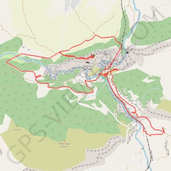
Niševačka klisura
- Distance: 9.5 Km
- Elevation gain: 404 m
- Maximum elevation: 469 m
- Elevation loss: 407 m
- Minimum elevation: 342 m
- Moving time: 3 h 2 m
- Moving speed: 3.1 Km/h
- Maximum speed: 5.5 Km/h
- Total time: 5 h 11 m
- Global speed: 1.8 Km/h
Interactive trail map
Trail profile
- Distance: 9.5 Km
- Elevation gain: 404 m
- Maximum elevation: 469 m
- Elevation loss: 407 m
- Minimum elevation: 342 m
- Moving time: 3 h 2 m
- Moving speed: 3.1 Km/h
- Maximum speed: 5.5 Km/h
- Total time: 5 h 11 m
- Global speed: 1.8 Km/h
About this trail
Name: Niševačka klisura trail, distance, elevation, map, profile, GPS track
Coordinates: 43.46380 22.07934 43.47667 22.10712
Other hiking, mountain biking, running and outdoor activity trails
Click on a trail to view its statistics, map and profile.
Niševačka klisura (Niševac) - kružna tura
Serbia > Central Serbia > Nisava Administrative District > Svrljig Municipality > Nisevac
Distance: 8.0 Km • Elevation gain: 446 m • Maximum elevation: 453 m