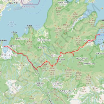
五肚入口Track
Outdoor hiking
- Distance: 8.1 Km
- Elevation gain: 337 m
- Maximum elevation: 271 m
- Elevation loss: 335 m
- Minimum elevation: -2 m
- Moving time: 1 h 49 m
- Moving speed: 4.5 Km/h
- Maximum speed: 15.9 Km/h
- Total time: 2 h 31 m
- Global speed: 3.2 Km/h
Interactive trail map
Trail profile
- Distance: 8.1 Km
- Elevation gain: 337 m
- Maximum elevation: 271 m
- Elevation loss: 335 m
- Minimum elevation: -2 m
- Moving time: 1 h 49 m
- Moving speed: 4.5 Km/h
- Maximum speed: 15.9 Km/h
- Total time: 2 h 31 m
- Global speed: 3.2 Km/h
About this trail
Name: 五肚入口Track trail, distance, elevation, map, profile, GPS track
Coordinates: 22.51370 114.21678 22.53007 114.26474
Other hiking, mountain biking, running and outdoor activity trails
Click on a trail to view its statistics, map and profile.
Wilson Trail Full Route
China > Hong Kong > Hong Kong Island
Distance: 81.2 Km • Elevation gain: 4,430 m • Maximum elevation: 613 m
下新娘潭坑左源 上新娘潭坑左源 屏嘉黃嘉下源
China > Hong Kong > North District > Wu Kau Tang > Sam Ka Tsuen
Hong Kong Hike
Distance: 13.6 Km • Elevation gain: 477 m • Maximum elevation: 257 m