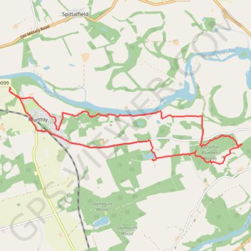
Murthly to Kinclaven Wood, Perthshire
Loop run / hike via Gellyburn, Murthly, River Tay, Ballathie Bluebell Woods and Old England Loch. #Running #Hiking #Loop #Nature #Forest #River #Countryside #Lake
- Distance: 14.5 Km
- Elevation gain: 136 m
- Maximum elevation: 82 m
- Elevation loss: 136 m
- Minimum elevation: 33 m
- Moving time: 1 h 27 m
- Moving speed: 10.0 Km/h
- Maximum speed: 34.0 Km/h
- Total time: 1 h 33 m
- Global speed: 9.3 Km/h
Interactive trail map
Trail profile
- Distance: 14.5 Km
- Elevation gain: 136 m
- Maximum elevation: 82 m
- Elevation loss: 136 m
- Minimum elevation: 33 m
- Moving time: 1 h 27 m
- Moving speed: 10.0 Km/h
- Maximum speed: 34.0 Km/h
- Total time: 1 h 33 m
- Global speed: 9.3 Km/h
About this trail
Name: Murthly to Kinclaven Wood, Perthshire trail, distance, elevation, map, profile, GPS track
Start: B9099, Gellyburn, Murthly, Perth and Kinross, Scotland, PH1 4HN, United Kingdom (56.53701 -3.47606)
End: B9099, Gellyburn, Murthly, Perth and Kinross, Scotland, PH1 4HN, United Kingdom (56.53696 -3.47600)
Coordinates: 56.52183 -3.47616 56.53701 -3.39273
Other hiking, mountain biking, running and outdoor activity trails
Click on a trail to view its statistics, map and profile.
Mountain Bike loop ride around Murthly, Perthshire Scotland
United Kingdom > Scotland > Perth and Kinross > Murthly > Gellyburn
UK, Perthshire, Dunkeld, Murthly
Distance: 18.0 Km • Elevation gain: 298 m • Maximum elevation: 178 m
Black Hill Roman Watch Tower - Around Meikleour, Perthshire
United Kingdom > Scotland > Perth and Kinross > Newlands
Distance: 19.4 Km • Elevation gain: 246 m • Maximum elevation: 138 m
EMTB Gravel: Murthly - Birnam - Loop
United Kingdom > Scotland > Perth and Kinross > Newlands
Around Dunkeld, Perthshire Scotland
Distance: 46.4 Km • Elevation gain: 869 m • Maximum elevation: 305 m
Kinclaven Wood - Stanley - Bankfoot Loop
United Kingdom > Scotland > Perth and Kinross > Newlands
Distance: 43.0 Km • Elevation gain: 547 m • Maximum elevation: 137 m
Gravel ride around Murthly Castle
United Kingdom > Scotland > Perth and Kinross > Murthly > Gellyburn
Distance: 10.0 Km • Elevation gain: 127 m • Maximum elevation: 123 m
King's Myre Loop
United Kingdom > Scotland > Perth and Kinross > Newlands
Distance: 39.8 Km • Elevation gain: 365 m • Maximum elevation: 106 m