Saint Mary's Lake and Saint Mary's Glacier in Arapaho National Forest
The hike to Saint Mary's Glacier is a fantastic choice for anyone looking to enjoy some stunning mountain views without a super long trek. You’ll find a lovely alpine lake early on, and if you're up for it, heading a bit higher offers even better scenery. Plus, spotting moose along the way adds a nice touch to this enjoyable, rocky trail. #Hiking #Mountain #Lake #Forest #Nature
- Distance: 3.1 Km
- Elevation gain: 159 m
- Maximum elevation: 3,311 m
- Elevation loss: 160 m
- Minimum elevation: 3,151 m
- Moving time: 1 h 19 m
- Moving speed: 2.4 Km/h
- Maximum speed: 5.3 Km/h
- Total time: 1 h 43 m
- Global speed: 1.8 Km/h
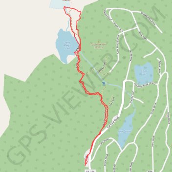
Interactive trail map
Trail profile
- Distance: 3.1 Km
- Elevation gain: 159 m
- Maximum elevation: 3,311 m
- Elevation loss: 160 m
- Minimum elevation: 3,151 m
- Moving time: 1 h 19 m
- Moving speed: 2.4 Km/h
- Maximum speed: 5.3 Km/h
- Total time: 1 h 43 m
- Global speed: 1.8 Km/h
About this trail
Name: Saint Mary's Lake and Saint Mary's Glacier in Arapaho National Forest trail, distance, elevation, map, profile, GPS track
Start: Lake Road, Clear Creek County, Colorado, United States (39.82499 -105.64475)
End: Lake Road, Clear Creek County, Colorado, United States (39.82487 -105.64475)
Coordinates: 39.82487 -105.64658 39.83537 -105.64278
Other hiking, mountain biking, running and outdoor activity trails
Click on a trail to view its statistics, map and profile.