Liberty State Park
- Distance: 7.0 Km
- Elevation gain: 16 m
- Maximum elevation: 5 m
- Elevation loss: 15 m
- Minimum elevation: -1 m
- Moving time: 1 h 40 m
- Moving speed: 4.2 Km/h
- Maximum speed: 7.1 Km/h
- Total time: 2 h 31 m
- Global speed: 2.8 Km/h
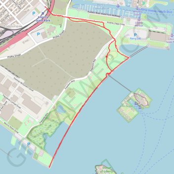
Interactive trail map
Trail profile
- Distance: 7.0 Km
- Elevation gain: 16 m
- Maximum elevation: 5 m
- Elevation loss: 15 m
- Minimum elevation: -1 m
- Moving time: 1 h 40 m
- Moving speed: 4.2 Km/h
- Maximum speed: 7.1 Km/h
- Total time: 2 h 31 m
- Global speed: 2.8 Km/h
About this trail
Name: Liberty State Park trail, distance, elevation, map, profile, GPS track
Coordinates: 40.69078 -74.05561 40.71116 -74.04159
Other hiking, mountain biking, running and outdoor activity trails
Click on a trail to view its statistics, map and profile.
Forever drawn in by the mystique of Kearny Point
United States > New Jersey > Hudson County > Jersey City
bike ride
Distance: 29.5 Km • Elevation gain: 201 m • Maximum elevation: 35 m