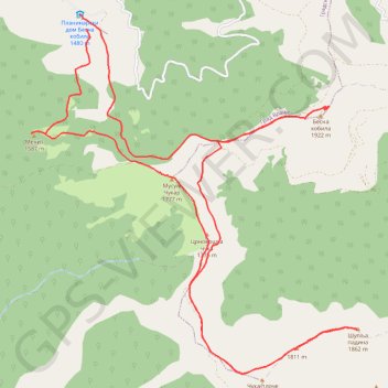
Trenutna trasa: 29 KOL 2015 09:15 001
- Distance: 20.2 Km
- Elevation gain: 943 m
- Maximum elevation: 1,909 m
- Elevation loss: 942 m
- Minimum elevation: 1,453 m
- Moving time: 4 h 53 m
- Moving speed: 4.1 Km/h
- Maximum speed: 6.9 Km/h
- Total time: 6 h 20 m
- Global speed: 3.2 Km/h
Interactive trail map
Trail profile
- Distance: 20.2 Km
- Elevation gain: 943 m
- Maximum elevation: 1,909 m
- Elevation loss: 942 m
- Minimum elevation: 1,453 m
- Moving time: 4 h 53 m
- Moving speed: 4.1 Km/h
- Maximum speed: 6.9 Km/h
- Total time: 6 h 20 m
- Global speed: 3.2 Km/h
About this trail
Name: Trenutna trasa: 29 KOL 2015 09:15 001 trail, distance, elevation, map, profile, GPS track
Coordinates: 42.50063 22.18665 42.54075 22.23604
Other hiking, mountain biking, running and outdoor activity trails
Click on a trail to view its statistics, map and profile.
Besna Kobila (1923m)-Veliki Streser (1878m)-Topli Do hiking,...
Serbia > Central Serbia > Pcinja Administrative District > Vranjska Banja > Kriva Feja > Barje
Distance: 27.1 Km • Elevation gain: 1,067 m • Maximum elevation: 1,907 m
Besna kobila: od pl.doma na vrhove Musulj Čukar, Besna kobil...
Serbia > Central Serbia > Pcinja Administrative District > Vranjska Banja > Kriva Feja > Barje
Distance: 18.9 Km • Elevation gain: 939 m • Maximum elevation: 1,917 m