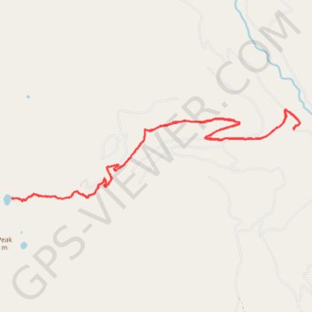
Afternoon hike at Fault Lake
- Distance: 19.3 Km
- Elevation gain: 884 m
- Maximum elevation: 1,828 m
- Elevation loss: 883 m
- Minimum elevation: 975 m
- Moving time: 4 h 9 m
- Moving speed: 4.6 Km/h
- Maximum speed: 8.7 Km/h
- Total time: 5 h 52 m
- Global speed: 3.3 Km/h
Interactive trail map
Trail profile
- Distance: 19.3 Km
- Elevation gain: 884 m
- Maximum elevation: 1,828 m
- Elevation loss: 883 m
- Minimum elevation: 975 m
- Moving time: 4 h 9 m
- Moving speed: 4.6 Km/h
- Maximum speed: 8.7 Km/h
- Total time: 5 h 52 m
- Global speed: 3.3 Km/h
About this trail
Name: Afternoon hike at Fault Lake trail, distance, elevation, map, profile, GPS track
Start: Boundary County, Idaho, United States (48.57655 -116.62181)
End: Boundary County, Idaho, United States (48.57657 -116.62188)
Coordinates: 48.56412 -116.69530 48.57998 -116.62026