Thank you for supporting this site ❤️
Make a donation
Make a donation
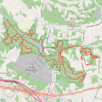
Chimney Rock
- Distance: 33.6 Km
- Elevation gain: 630 m
- Maximum elevation: 127 m
- Elevation loss: 630 m
- Minimum elevation: 47 m
- Moving time: 3 h 18 m
- Moving speed: 10.1 Km/h
- Maximum speed: 35.9 Km/h
- Total time: 3 h 40 m
- Global speed: 9.1 Km/h
Interactive trail map
Thank you for supporting this site ❤️
Make a donation
Make a donation
Trail profile
- Distance: 33.6 Km
- Elevation gain: 630 m
- Maximum elevation: 127 m
- Elevation loss: 630 m
- Minimum elevation: 47 m
- Moving time: 3 h 18 m
- Moving speed: 10.1 Km/h
- Maximum speed: 35.9 Km/h
- Total time: 3 h 40 m
- Global speed: 9.1 Km/h
Thank you for supporting this site ❤️
Make a donation
Make a donation
About this trail
Name: Chimney Rock trail, distance, elevation, map, profile, GPS track
Coordinates: 40.57945 -74.58250 40.60307 -74.53659
Thank you for supporting this site ❤️
Make a donation
Make a donation