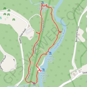
Swallow Falls Canyon Loop Trail in Swallow Falls State Park
The Swallow Falls Canyon Loop Trail offers a scenic, moderately easy hike through an area known for its lush forests and beautiful waterfalls. As you walk, you'll pass by the majestic Muddy Creek Falls, which is Maryland’s tallest waterfall, along with Swallow Falls, Lower Swallow Falls, and Tolliver Falls. The trail features a mix of gravel paths and rugged sections, with steps in some places, providing both natural beauty and a mild challenge for hikers. #Hiking #Loop #Waterfall #Canyon #River #Forest #Nature
- Distance: 1.9 Km
- Elevation gain: 46 m
- Maximum elevation: 725 m
- Elevation loss: 47 m
- Minimum elevation: 689 m
- Moving time: 45 m 35 s
- Moving speed: 2.5 Km/h
- Maximum speed: 5.5 Km/h
- Total time: 1 h 17 m
- Global speed: 1.4 Km/h
Interactive trail map
Trail profile
- Distance: 1.9 Km
- Elevation gain: 46 m
- Maximum elevation: 725 m
- Elevation loss: 47 m
- Minimum elevation: 689 m
- Moving time: 45 m 35 s
- Moving speed: 2.5 Km/h
- Maximum speed: 5.5 Km/h
- Total time: 1 h 17 m
- Global speed: 1.4 Km/h
About this trail
Name: Swallow Falls Canyon Loop Trail in Swallow Falls State Park trail, distance, elevation, map, profile, GPS track
Start: Canyon Trail, Garrett County, Maryland, United States (39.49882 -79.41772)
End: Canyon Trail, Garrett County, Maryland, United States (39.49894 -79.41796)
Coordinates: 39.49502 -79.41900 39.50113 -79.41549