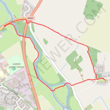
River Nene Loop from Ashton
- Distance: 3.3 Km
- Elevation gain: 25 m
- Maximum elevation: 43 m
- Elevation loss: 25 m
- Minimum elevation: 20 m
- Moving time: 53 m 5 s
- Moving speed: 3.8 Km/h
- Maximum speed: 5.8 Km/h
- Total time: 54 m 44 s
- Global speed: 3.7 Km/h
Interactive trail map
Trail profile
- Distance: 3.3 Km
- Elevation gain: 25 m
- Maximum elevation: 43 m
- Elevation loss: 25 m
- Minimum elevation: 20 m
- Moving time: 53 m 5 s
- Moving speed: 3.8 Km/h
- Maximum speed: 5.8 Km/h
- Total time: 54 m 44 s
- Global speed: 3.7 Km/h
About this trail
Name: River Nene Loop from Ashton trail, distance, elevation, map, profile, GPS track
Start: Ashton, North Northamptonshire, England, PE8 5LD, United Kingdom (52.48238 -0.44653)
End: The Green, Ashton, North Northamptonshire, England, PE8 5LD, United Kingdom (52.48214 -0.44622)
Coordinates: 52.48111 -0.46330 52.48843 -0.44622