Ridge, Panorama, and Bluffs Loop Trail in Andrew Molera State Park
The Ridge, Panorama, and Bluffs Loop in Andrew Molera State Park offers a striking variety of landscapes, from peaceful meadows and the rugged Big Sur River to sweeping coastal views and the forested ridges. Hikers will enjoy diverse vistas, including expansive looks at the Pacific Ocean, and may even encounter secluded beaches along the Bluffs Trail. With its well-maintained paths and notable historical landmarks, like Cooper Cabin, this loop provides a rewarding mix of natural beauty and outdoor adventure. #Hiking #Loop #Nature #Overlook #Pacific #Ocean #Sea #Beach
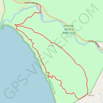
- Distance: 12.9 Km
- Elevation gain: 451 m
- Maximum elevation: 334 m
- Elevation loss: 458 m
- Minimum elevation: 7 m
- Moving time: 2 h 48 m
- Moving speed: 4.6 Km/h
- Maximum speed: 6.4 Km/h
- Total time: 3 h 9 m
- Global speed: 4.1 Km/h
Interactive trail map
Trail profile
- Distance: 12.9 Km
- Elevation gain: 451 m
- Maximum elevation: 334 m
- Elevation loss: 458 m
- Minimum elevation: 7 m
- Moving time: 2 h 48 m
- Moving speed: 4.6 Km/h
- Maximum speed: 6.4 Km/h
- Total time: 3 h 9 m
- Global speed: 4.1 Km/h
About this trail
Name: Ridge, Panorama, and Bluffs Loop Trail in Andrew Molera State Park trail, distance, elevation, map, profile, GPS track
Start: Cabrillo Highway, Big Sur Village, Monterey County, California, United States (36.28846 -121.84403)
End: Andrew Molera State Park Entrance, Monterey County, California, United States (36.28787 -121.84357)
Coordinates: 36.25516 -121.85421 36.28846 -121.82271