Trails and canal from Silsden
- Distance: 5.0 Km
- Elevation gain: 68 m
- Maximum elevation: 157 m
- Elevation loss: 67 m
- Minimum elevation: 104 m
- Moving time: 53 m 39 s
- Moving speed: 5.6 Km/h
- Maximum speed: 15.6 Km/h
- Total time: 53 m 39 s
- Global speed: 5.6 Km/h
Interactive trail map
Trail profile
- Distance: 5.0 Km
- Elevation gain: 68 m
- Maximum elevation: 157 m
- Elevation loss: 67 m
- Minimum elevation: 104 m
- Moving time: 53 m 39 s
- Moving speed: 5.6 Km/h
- Maximum speed: 15.6 Km/h
- Total time: 53 m 39 s
- Global speed: 5.6 Km/h
About this trail
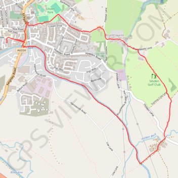
Name: Trails and canal from Silsden trail, distance, elevation, map, profile, GPS track
Coordinates: 53.90129 -1.94040 53.91421 -1.91626
Other hiking, mountain biking, running and outdoor activity trails
Click on a trail to view its statistics, map and profile.
Otley - Draughton/Skipton Moor and return
United Kingdom > England > Leeds
Distance: 41.3 Km • Elevation gain: 456 m • Maximum elevation: 318 m