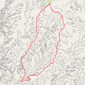
Squaw Canyon Loop
Loop hike on Quaw Canyon Trail, Wooden Shoe Canyon Trail and Big Spring Canyon Trail in the Canyonlands National Park. #Hiking #Loop #Canyon #Mountain #Nature #Park
- Distance: 11.9 Km
- Elevation gain: 257 m
- Maximum elevation: 1,714 m
- Elevation loss: 258 m
- Minimum elevation: 1,553 m
- Moving time: 4 h 57 s
- Moving speed: 3.0 Km/h
- Maximum speed: 6.4 Km/h
- Total time: 5 h 24 m
- Global speed: 2.2 Km/h
Interactive trail map
Trail profile
- Distance: 11.9 Km
- Elevation gain: 257 m
- Maximum elevation: 1,714 m
- Elevation loss: 258 m
- Minimum elevation: 1,553 m
- Moving time: 4 h 57 s
- Moving speed: 3.0 Km/h
- Maximum speed: 6.4 Km/h
- Total time: 5 h 24 m
- Global speed: 2.2 Km/h
About this trail
Name: Squaw Canyon Loop trail, distance, elevation, map, profile, GPS track
Coordinates: 38.10765 -109.82016 38.14350 -109.79491
Other hiking, mountain biking, running and outdoor activity trails
Click on a trail to view its statistics, map and profile.