Crags Hotel Ruins and Continental Divide Overlook
Eldorado Canyon State Park. #Hiking #Snowshoeing #Mountain #Forest #Nature
- Distance: 4.7 Km
- Elevation gain: 317 m
- Maximum elevation: 2,078 m
- Elevation loss: 317 m
- Minimum elevation: 1,857 m
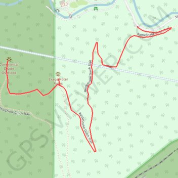
Interactive trail map
Trail profile
- Distance: 4.7 Km
- Elevation gain: 317 m
- Maximum elevation: 2,078 m
- Elevation loss: 317 m
- Minimum elevation: 1,857 m
About this trail
Name: Crags Hotel Ruins and Continental Divide Overlook trail, distance, elevation, map, profile, GPS track
Start: RattleSnake Gulch Trail, Boulder County, Colorado, 80025, United States (39.92949 -105.29004)
End: RattleSnake Gulch Trail, Boulder County, Colorado, 80025, United States (39.92949 -105.29004)
Coordinates: 39.92353 -105.29813 39.92949 -105.28794
Other hiking, mountain biking, running and outdoor activity trails
Click on a trail to view its statistics, map and profile.
Rattlesnake Gulch Trail in Eldorado Canyon State Park
United States > Colorado > Boulder County
The Rattlesnake Gulch Trail in Eldorado Canyon State Park offers hikers captivating views of towering canyon walls and the serene South Boulder Creek. Midway, explorers encounter the remnants of the historic Crags Hotel, which operated in the early 1900s before succumbing to a fire. At the trail's apex, the…
Distance: 4.9 Km • Elevation gain: 293 m • Maximum elevation: 2,081 m
New Eldorado Canyon bridge
United States > Colorado > Boulder County > Eldorado Springs
Distance: 3.0 Km • Elevation gain: 289 m • Maximum elevation: 2,094 m