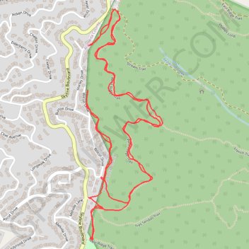
Hike in Reinhardt-Redwood Regional Park
- Distance: 5.8 Km
- Elevation gain: 243 m
- Maximum elevation: 449 m
- Elevation loss: 243 m
- Minimum elevation: 376 m
- Moving time: 1 h 9 m
- Moving speed: 5.0 Km/h
- Maximum speed: 19.8 Km/h
- Total time: 1 h 11 m
- Global speed: 4.8 Km/h
Interactive trail map
Trail profile
- Distance: 5.8 Km
- Elevation gain: 243 m
- Maximum elevation: 449 m
- Elevation loss: 243 m
- Minimum elevation: 376 m
- Moving time: 1 h 9 m
- Moving speed: 5.0 Km/h
- Maximum speed: 19.8 Km/h
- Total time: 1 h 11 m
- Global speed: 4.8 Km/h
About this trail
Name: Hike in Reinhardt-Redwood Regional Park trail, distance, elevation, map, profile, GPS track
Start: West Ridge Trail, Contra Costa County, California, 94516, United States (37.83140 -122.18526)
Coordinates: 37.82162 -122.18686 37.83144 -122.18275
Other hiking, mountain biking, running and outdoor activity trails
Click on a trail to view its statistics, map and profile.
Reinhardt Redwood Regional Park West Loop
United States > California > Contra Costa County > Canyon
Distance: 7.9 Km • Elevation gain: 385 m • Maximum elevation: 408 m
West Ridge, French and Stream Trails Loop
United States > California > Contra Costa County
From Skyline Gate, the loop first follows West Ridge Trail along the higher western edge of Reinhardt Redwood Regional Park, with evergreen woodland, chaparral openings, and views over the forested Redwood Creek basin. It then turns onto French Trail, crossing the quieter interior slopes past side-trail…
Distance: 7.3 Km • Elevation gain: 344 m • Maximum elevation: 407 m
West Ridge, French and Stream Trails Loop in Reinhardt Redwood Regional Park
United States > California > Contra Costa County
The West Ridge, French, and Stream Trails Loop in Reinhardt Redwood Regional Park offers hikers a serene journey through towering coast redwoods, providing ample shade and a tranquil atmosphere. As you navigate the well-marked paths, you'll encounter diverse flora, including ferns and wildflowers, and may spot…
Distance: 7.8 Km • Elevation gain: 402 m • Maximum elevation: 409 m
Loop hike in Reinhardt Redwood Regional Park
United States > California > Contra Costa County
Distance: 5.8 Km • Elevation gain: 210 m • Maximum elevation: 409 m