Realtor Park
- Distance: 2.0 Km
- Elevation gain: 6 m
- Maximum elevation: 182 m
- Elevation loss: 5 m
- Minimum elevation: 178 m
- Moving time: 8 m 21 s
- Moving speed: 14.3 Km/h
- Maximum speed: 19.7 Km/h
- Total time: 8 m 21 s
- Global speed: 14.3 Km/h
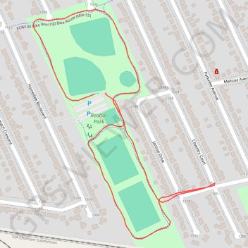
Interactive trail map
Trail profile
- Distance: 2.0 Km
- Elevation gain: 6 m
- Maximum elevation: 182 m
- Elevation loss: 5 m
- Minimum elevation: 178 m
- Moving time: 8 m 21 s
- Moving speed: 14.3 Km/h
- Maximum speed: 19.7 Km/h
- Total time: 8 m 21 s
- Global speed: 14.3 Km/h
About this trail
Name: Realtor Park trail, distance, elevation, map, profile, GPS track
Start: Homedale Boulevard, Windsor, Ontario, N8S 2A6, Canada (42.32274 -82.95328)
End: Homedale Boulevard, Windsor, Ontario, N8S 2A6, Canada (42.32273 -82.95361)
Coordinates: 42.31947 -82.95547 42.32463 -82.94994