Import a GPX file

Rosewall Creek Provincial Park

Vancouver Island. #Hiking #Rosewall #Vancouver

  • Distance: 5.8 Km
  • Elevation gain: 137 m
  • Maximum elevation: 93 m
  • Elevation loss: 137 m
  • Minimum elevation: 22 m

Interactive trail map
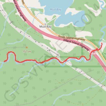
Trail profile

  • Distance: 5.8 Km
  • Elevation gain: 137 m
  • Maximum elevation: 93 m
  • Elevation loss: 137 m
  • Minimum elevation: 22 m

About this trail

Name: Rosewall Creek Provincial Park trail, distance, elevation, map, profile, GPS track

Start: Berray Road, Area A (Baynes Sound), Comox Valley Regional District, British Columbia, Canada (49.45650 -124.77511)

End: Berray Road, Area A (Baynes Sound), Comox Valley Regional District, British Columbia, Canada (49.45650 -124.77511)

Coordinates: 49.45271 -124.80372 49.45650 -124.77506

Other hiking, mountain biking, running and outdoor activity trails

Click on a trail to view its statistics, map and profile.

Deep Bay - Port Alberni - Cumberland

Canada > British Columbia > Regional District of Nanaimo > Area H (Lighthouse Country)

Vancouver Island. #Bike #Loop #Vancouver

Distance: 149.7 Km • Elevation gain: 3,366 m • Maximum elevation: 465 m

Nanaimo - Fanny Bay

Canada > British Columbia > Regional District of Nanaimo > Nanaimo

Vancouver Island. #Bike #Nanaimo #Fanny #Vancouver

Distance: 72.4 Km • Elevation gain: 664 m • Maximum elevation: 123 m