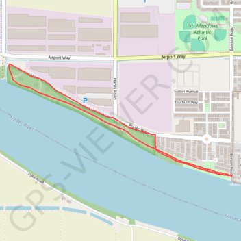
Pitt Meadows Regional Greenway
Harris Landing Park. Shoreline Park. Fraser River. #Hiking #MTB #Running #HarrisLanding
- Distance: 3.7 Km
- Elevation gain: 17 m
- Maximum elevation: 11 m
- Elevation loss: 17 m
- Minimum elevation: 3 m
Interactive trail map
Trail profile
- Distance: 3.7 Km
- Elevation gain: 17 m
- Maximum elevation: 11 m
- Elevation loss: 17 m
- Minimum elevation: 3 m
About this trail
Name: Pitt Meadows Regional Greenway trail, distance, elevation, map, profile, GPS track
Coordinates: 49.20049 -122.70018 49.20773 -122.67827
Other hiking, mountain biking, running and outdoor activity trails
Click on a trail to view its statistics, map and profile.