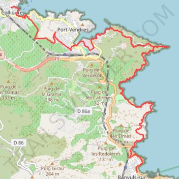
1.1 Collioure-Banyuls Littoral
- Distance: 16.2 Km
- Elevation gain: 617 m
- Maximum elevation: 146 m
- Elevation loss: 620 m
- Minimum elevation: 0 m
- Moving time: 3 h 43 m
- Moving speed: 4.3 Km/h
- Maximum speed: 12.6 Km/h
- Total time: 4 h 18 m
- Global speed: 3.7 Km/h
Interactive trail map
Trail profile
- Distance: 16.2 Km
- Elevation gain: 617 m
- Maximum elevation: 146 m
- Elevation loss: 620 m
- Minimum elevation: 0 m
- Moving time: 3 h 43 m
- Moving speed: 4.3 Km/h
- Maximum speed: 12.6 Km/h
- Total time: 4 h 18 m
- Global speed: 3.7 Km/h
About this trail
Name: 1.1 Collioure-Banyuls Littoral trail, distance, elevation, map, profile, GPS track
Coordinates: 42.48156 3.08290 42.52655 3.14078
Other hiking, mountain biking, running and outdoor activity trails
Click on a trail to view its statistics, map and profile.
GR 10 - Traversée des Pyrénées
France > Occitania > Pyrénées-Orientales > Banyuls-sur-Mer
Distance: 874.8 Km • Elevation gain: 57,000 m • Maximum elevation: 2,599 m
1 LUCENA - MONTPELLIER
Distance: 2,964.4 Km • Elevation gain: 29,500 m • Maximum elevation: 1,048 m
PT23DS2 Lörrach → Cadaqués
Germany > Baden-Württemberg > Landkreis Lörrach > Lörrach (Kernstadt)
Distance: 1,050.7 Km • Elevation gain: 13,130 m • Maximum elevation: 1,505 m
Southern section — European Divide Trail
France > Auvergne-Rhône-Alpes > Drôme > Valence
Distance: 2,423.8 Km • Elevation gain: 42,375 m • Maximum elevation: 2,005 m