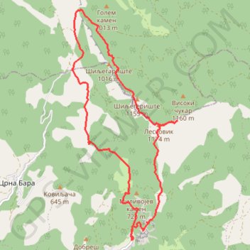
Planina Ozren od manastira Sveti Stevan u Lipovcu
- Distance: 15.6 Km
- Elevation gain: 990 m
- Maximum elevation: 1,173 m
- Elevation loss: 995 m
- Minimum elevation: 398 m
- Moving time: 6 h 33 m
- Moving speed: 2.4 Km/h
- Maximum speed: 61.1 Km/h
- Total time: 8 h 25 m
- Global speed: 1.8 Km/h
Interactive trail map
Trail profile
- Distance: 15.6 Km
- Elevation gain: 990 m
- Maximum elevation: 1,173 m
- Elevation loss: 995 m
- Minimum elevation: 398 m
- Moving time: 6 h 33 m
- Moving speed: 2.4 Km/h
- Maximum speed: 61.1 Km/h
- Total time: 8 h 25 m
- Global speed: 1.8 Km/h
About this trail
Name: Planina Ozren od manastira Sveti Stevan u Lipovcu trail, distance, elevation, map, profile, GPS track
Coordinates: 43.56080 21.81824 43.60586 21.84663
Other hiking, mountain biking, running and outdoor activity trails
Click on a trail to view its statistics, map and profile.
2022_Yu
Slovenia > Ajdovščina > Žapuže
Distance: 2,457.3 Km • Elevation gain: 32,048 m • Maximum elevation: 1,950 m
2018-06-16 14:28:41 Dan
Serbia > Central Serbia > Zajecar Administrative District > Sokobanja Municipality > Resnik
Distance: 3.8 Km • Elevation gain: 1 m • Maximum elevation: 1,167 m