Clifty Falls, Wallace Falls, Hoffman Falls and Tunnel Falls Loop in Clifty Falls State Park
The Clifty Falls, Wallace Falls, Hoffman Falls, and Tunnel Falls Loop offers a remarkable hiking experience through diverse landscapes and stunning natural features. As you traverse the trail, you'll encounter beautiful waterfalls cascading into serene pools, lush forests, and impressive rock formations, creating a picturesque backdrop for your adventure. The path is well-maintained and varies in difficulty, making it accessible for a wide range of hikers while providing ample opportunities for photography and wildlife observation. #Hiking #Loop #Waterfall #Cliff #River #Forest #Nature
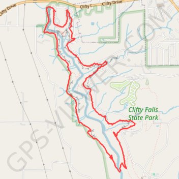
- Distance: 10.2 Km
- Elevation gain: 277 m
- Maximum elevation: 255 m
- Elevation loss: 277 m
- Minimum elevation: 156 m
- Moving time: 2 h 11 m
- Moving speed: 4.7 Km/h
- Maximum speed: 16.8 Km/h
- Total time: 2 h 24 m
- Global speed: 4.2 Km/h
Interactive trail map
Trail profile
- Distance: 10.2 Km
- Elevation gain: 277 m
- Maximum elevation: 255 m
- Elevation loss: 277 m
- Minimum elevation: 156 m
- Moving time: 2 h 11 m
- Moving speed: 4.7 Km/h
- Maximum speed: 16.8 Km/h
- Total time: 2 h 24 m
- Global speed: 4.2 Km/h
About this trail
Name: Clifty Falls, Wallace Falls, Hoffman Falls and Tunnel Falls Loop in Clifty Falls State Park trail, distance, elevation, map, profile, GPS track
Start: Trail 8, Jefferson County, Indiana, United States (38.76940 -85.43665)
End: Jefferson County, Indiana, United States (38.76963 -85.43683)
Coordinates: 38.74524 -85.43884 38.77018 -85.42124