Chasm Lake
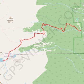
Interactive trail map
Trail profile
- Distance: 13.3 Km
- Elevation gain: 782 m
- Maximum elevation: 3,602 m
- Elevation loss: 782 m
- Minimum elevation: 2,860 m
About this trail
Name: Chasm Lake trail, distance, elevation, map, profile, GPS track
Start: Longs Peak Trailhead, Longs Peak Road, Larimer County, Colorado, United States (40.27198 -105.55655)
End: Longs Peak Trailhead, Longs Peak Road, Larimer County, Colorado, United States (40.27198 -105.55655)
Coordinates: 40.25814 -105.60312 40.27534 -105.55655
Other hiking, mountain biking, running and outdoor activity trails
Click on a trail to view its statistics, map and profile.
Chasm Lake via East Longs Peak Trail and Chasm Lake Trail
United States > Colorado > Larimer County
The hike to Chasm Lake in Rocky Mountain National Park is a rewarding journey through diverse alpine landscapes. Starting from the Longs Peak Trailhead, the trail gradually ascends through a dense forest of spruce and pine before breaking above the treeline, where sweeping views of Mount Meeker, Mount Lady…
Distance: 13.1 Km • Elevation gain: 785 m • Maximum elevation: 3,601 m