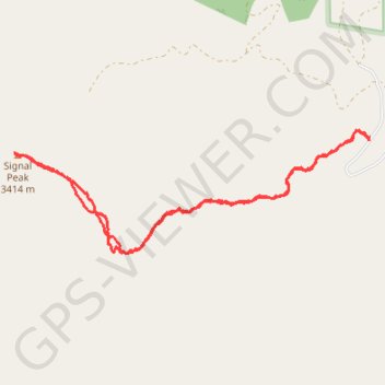
Glenwood Mountain
- Distance: 7.8 Km
- Elevation gain: 386 m
- Maximum elevation: 3,414 m
- Elevation loss: 386 m
- Minimum elevation: 3,107 m
- Moving time: 2 h 41 m
- Moving speed: 2.9 Km/h
- Maximum speed: 7.8 Km/h
- Total time: 3 h 25 m
- Global speed: 2.3 Km/h
Interactive trail map
Trail profile
- Distance: 7.8 Km
- Elevation gain: 386 m
- Maximum elevation: 3,414 m
- Elevation loss: 386 m
- Minimum elevation: 3,107 m
- Moving time: 2 h 41 m
- Moving speed: 2.9 Km/h
- Maximum speed: 7.8 Km/h
- Total time: 3 h 25 m
- Global speed: 2.3 Km/h
About this trail
Name: Glenwood Mountain trail, distance, elevation, map, profile, GPS track
Start: Monroe Mountain Road, Sevier County, Utah, United States (38.62623 -111.98462)
End: Monroe Mountain Road, Sevier County, Utah, United States (38.62621 -111.98461)
Coordinates: 38.61843 -112.01571 38.62693 -111.98455