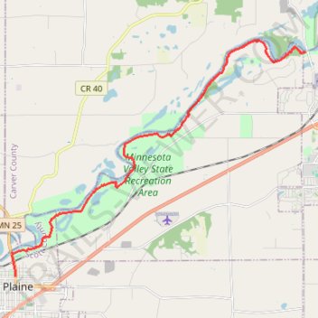
Minnesota river valley state trail, Belle Plaine to Jordan
- Distance: 16.3 Km
- Elevation gain: 106 m
- Maximum elevation: 258 m
- Elevation loss: 144 m
- Minimum elevation: 214 m
- Moving time: 1 h 53 m
- Moving speed: 8.6 Km/h
- Maximum speed: 29.2 Km/h
- Total time: 2 h 1 m
- Global speed: 8.0 Km/h
Interactive trail map
Trail profile
- Distance: 16.3 Km
- Elevation gain: 106 m
- Maximum elevation: 258 m
- Elevation loss: 144 m
- Minimum elevation: 214 m
- Moving time: 1 h 53 m
- Moving speed: 8.6 Km/h
- Maximum speed: 29.2 Km/h
- Total time: 2 h 1 m
- Global speed: 8.0 Km/h
About this trail
Name: Minnesota river valley state trail, Belle Plaine to Jordan trail, distance, elevation, map, profile, GPS track
Coordinates: 44.62564 -93.76516 44.69549 -93.64276