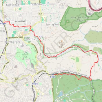
Belair National Park - Brownhill Creek
Interactive trail map
Trail profile
- Distance: 9.2 Km
- Elevation gain: 60 m
- Maximum elevation: 329 m
- Elevation loss: 292 m
- Minimum elevation: 78 m
About this trail
Name: Belair National Park - Brownhill Creek trail, distance, elevation, map, profile, GPS track
Coordinates: -35.00028 138.60967 -34.97744 138.65453
Other hiking, mountain biking, running and outdoor activity trails
Click on a trail to view its statistics, map and profile.
Belair National Park - Mount Lofty
Australia > South Australia > Adelaide
#Bike
Distance: 13.0 Km • Elevation gain: 503 m • Maximum elevation: 704 m
Belair National Park - Goodwood
Australia > South Australia > Adelaide
#Bike
Distance: 12.6 Km • Elevation gain: 36 m • Maximum elevation: 324 m