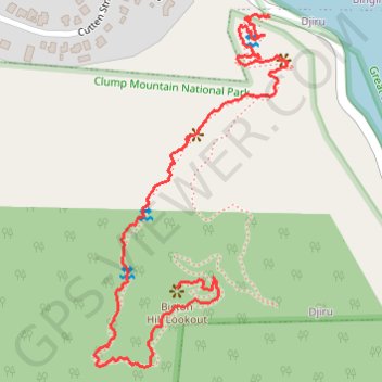
Bicton Hill walking track
Bicton Hill Lookout
- Distance: 2.1 Km
- Elevation gain: 171 m
- Maximum elevation: 172 m
- Elevation loss: 21 m
- Minimum elevation: 19 m
- Moving time: 35 m 46 s
- Moving speed: 3.5 Km/h
- Maximum speed: 13.9 Km/h
- Total time: 1 h 48 m
- Global speed: 1.2 Km/h
Interactive trail map
Trail profile
- Distance: 2.1 Km
- Elevation gain: 171 m
- Maximum elevation: 172 m
- Elevation loss: 21 m
- Minimum elevation: 19 m
- Moving time: 35 m 46 s
- Moving speed: 3.5 Km/h
- Maximum speed: 13.9 Km/h
- Total time: 1 h 48 m
- Global speed: 1.2 Km/h
About this trail
Name: Bicton Hill walking track trail, distance, elevation, map, profile, GPS track
Coordinates: -17.84253 146.09713 -17.83584 146.10097