Hiking Maughan Hollow
- Distance: 8.9 Km
- Elevation gain: 322 m
- Maximum elevation: 1,989 m
- Elevation loss: 323 m
- Minimum elevation: 1,682 m
- Moving time: 1 h 54 m
- Moving speed: 4.6 Km/h
- Maximum speed: 8.0 Km/h
- Total time: 2 h 10 m
- Global speed: 4.1 Km/h
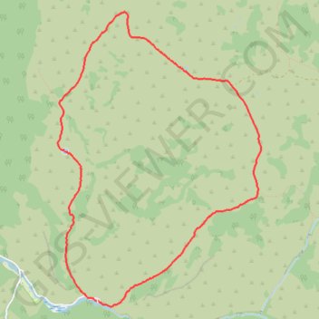
Interactive trail map
Trail profile
- Distance: 8.9 Km
- Elevation gain: 322 m
- Maximum elevation: 1,989 m
- Elevation loss: 323 m
- Minimum elevation: 1,682 m
- Moving time: 1 h 54 m
- Moving speed: 4.6 Km/h
- Maximum speed: 8.0 Km/h
- Total time: 2 h 10 m
- Global speed: 4.1 Km/h
About this trail
Name: Hiking Maughan Hollow trail, distance, elevation, map, profile, GPS track
Start: Right Hand Fork Road, Cache County, Utah, United States (41.77488 -111.61007)
End: Right Hand Fork Road, Cache County, Utah, United States (41.77491 -111.61026)
Coordinates: 41.77437 -111.61526 41.80246 -111.58928
Other hiking, mountain biking, running and outdoor activity trails
Click on a trail to view its statistics, map and profile.
Little Cottonwood Trail
United States > Utah > Cache County
Hiking
Distance: 11.0 Km • Elevation gain: 357 m • Maximum elevation: 2,019 m