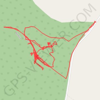
RE SJ800240 2
- Distance: 2.4 Km
- Elevation gain: 31 m
- Maximum elevation: 137 m
- Elevation loss: 31 m
- Minimum elevation: 117 m
- Moving time: 41 m 19 s
- Moving speed: 3.4 Km/h
- Maximum speed: 6.0 Km/h
- Total time: 2 d 23 h
- Global speed: 0.0 Km/h
Interactive trail map
Trail profile
- Distance: 2.4 Km
- Elevation gain: 31 m
- Maximum elevation: 137 m
- Elevation loss: 31 m
- Minimum elevation: 117 m
- Moving time: 41 m 19 s
- Moving speed: 3.4 Km/h
- Maximum speed: 6.0 Km/h
- Total time: 2 d 23 h
- Global speed: 0.0 Km/h
About this trail
Name: RE SJ800240 2 trail, distance, elevation, map, profile, GPS track
Coordinates: 52.81284 -2.29932 52.81463 -2.29458
Other hiking, mountain biking, running and outdoor activity trails
Click on a trail to view its statistics, map and profile.
RE SJ800240
United Kingdom > England > Staffordshire > Stafford > Gnosall > Knightley
Distance: 1.9 Km • Elevation gain: 33 m • Maximum elevation: 137 m