Crowder Canyon
Hike through the Crowder Canyon via Pacific Crest National Scenic Trail (PCT) in the San Bernardino National Forest. #Hiking #Mountain #Nature #Canyon #Forest #PCT
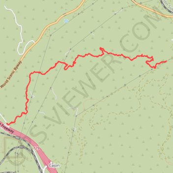
- Distance: 12.0 Km
- Elevation gain: 485 m
- Maximum elevation: 1,221 m
- Elevation loss: 484 m
- Minimum elevation: 920 m
- Moving time: 2 h 39 m
- Moving speed: 4.5 Km/h
- Maximum speed: 35.6 Km/h
- Total time: 2 h 49 m
- Global speed: 4.2 Km/h
Interactive trail map
Trail profile
- Distance: 12.0 Km
- Elevation gain: 485 m
- Maximum elevation: 1,221 m
- Elevation loss: 484 m
- Minimum elevation: 920 m
- Moving time: 2 h 39 m
- Moving speed: 4.5 Km/h
- Maximum speed: 35.6 Km/h
- Total time: 2 h 49 m
- Global speed: 4.2 Km/h
About this trail
Name: Crowder Canyon trail, distance, elevation, map, profile, GPS track
Coordinates: 34.30599 -117.46671 34.31967 -117.43218
Other hiking, mountain biking, running and outdoor activity trails
Click on a trail to view its statistics, map and profile.