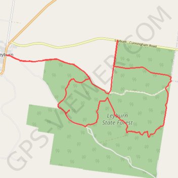
Leyburn State Forest
Interactive trail map
Trail profile
- Distance: 27.4 Km
- Elevation gain: 494 m
- Maximum elevation: 569 m
- Elevation loss: 494 m
- Minimum elevation: 415 m
About this trail
Name: Leyburn State Forest trail, distance, elevation, map, profile, GPS track
Start: Leyburn Forestry Road, Leyburn, Southern Downs Regional, Queensland, Australia (-28.01021 151.58650)
End: Leyburn Forestry Road, Leyburn, Southern Downs Regional, Queensland, Australia (-28.01020 151.58647)
Coordinates: -28.04192 151.58647 -28.00460 151.65822
Other hiking, mountain biking, running and outdoor activity trails
Click on a trail to view its statistics, map and profile.