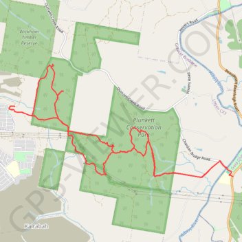
Plunkett Conservation Park - Yarrabilba
Interactive trail map
Trail profile
- Distance: 17.1 Km
- Elevation gain: 413 m
- Maximum elevation: 158 m
- Elevation loss: 429 m
- Minimum elevation: 16 m
About this trail
Name: Plunkett Conservation Park - Yarrabilba trail, distance, elevation, map, profile, GPS track
Start: Beaudesert Beenleigh Road, Cedar Creek, Gold Coast City, Queensland, Australia (-27.82741 153.18013)
End: Chardon Bridge Road, Cedar Creek, Gold Coast City, Queensland, Australia (-27.82580 153.17893)
Coordinates: -27.82759 153.13257 -27.80640 153.18013