Thank you for supporting this site ❤️
Make a donation
Make a donation
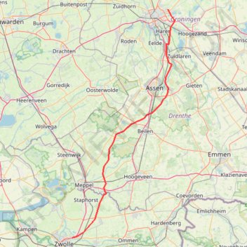
Zwolle - Groningen
- Distance: 98.6 Km
- Elevation gain: 40 m
- Maximum elevation: 18 m
- Elevation loss: 43 m
- Minimum elevation: -1 m
Interactive trail map
Thank you for supporting this site ❤️
Make a donation
Make a donation
Trail profile
- Distance: 98.6 Km
- Elevation gain: 40 m
- Maximum elevation: 18 m
- Elevation loss: 43 m
- Minimum elevation: -1 m
Thank you for supporting this site ❤️
Make a donation
Make a donation
About this trail
Name: Zwolle - Groningen trail, distance, elevation, map, profile, GPS track
Start: Rijksweg A28, Berkum, Zwolle, Overijssel, Netherlands, 8034 PM, Netherlands (52.52856 6.13871)
Coordinates: 52.52856 6.13871 53.23828 6.66479
Thank you for supporting this site ❤️
Make a donation
Make a donation
Other hiking, mountain biking, running and outdoor activity trails
Click on a trail to view its statistics, map and profile.
My Vessel Track
Netherlands > Frisia > Workum
Distance: 324.2 Km • Elevation gain: 86 m • Maximum elevation: 5 m