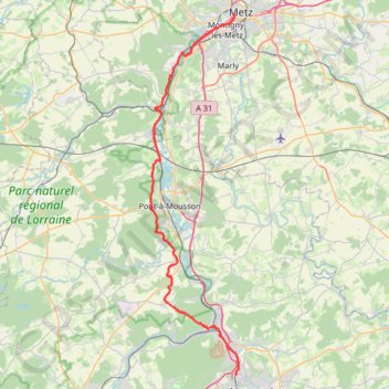
Marche Nancy - Metz
- Distance: 64.6 Km
- Elevation gain: 810 m
- Maximum elevation: 356 m
- Elevation loss: 836 m
- Minimum elevation: 165 m
Interactive trail map
Trail profile
- Distance: 64.6 Km
- Elevation gain: 810 m
- Maximum elevation: 356 m
- Elevation loss: 836 m
- Minimum elevation: 165 m
About this trail
Name: Marche Nancy - Metz trail, distance, elevation, map, profile, GPS track
Coordinates: 48.71230 6.02274 49.11660 6.17355
Other hiking, mountain biking, running and outdoor activity trails
Click on a trail to view its statistics, map and profile.
Riethoven naar Oostenrijk
Netherlands > North Brabant > Riethoven > Eind
Distance: 922.1 Km • Elevation gain: 13,629 m • Maximum elevation: 1,897 m
Eurovelo 15 - Strasbourg Rotterdam
France > Grand Est > Bas-Rhin > Strasbourg
Distance: 891.7 Km • Elevation gain: 2,104 m • Maximum elevation: 146 m