Make a donation
2026-04-09--22-57-26
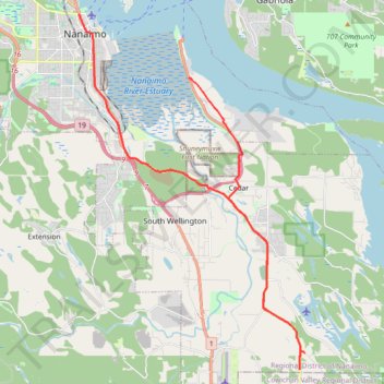
- Distance: 29.5 Km
- Elevation gain: 301 m
- Maximum elevation: 52 m
- Elevation loss: 306 m
- Minimum elevation: 5 m
- Moving time: 34 m 53 s
- Moving speed: 50.8 Km/h
- Maximum speed: 80.8 Km/h
- Total time: 36 m 16 s
- Global speed: 48.9 Km/h
Interactive trail map
Make a donation
Trail profile
- Distance: 29.5 Km
- Elevation gain: 301 m
- Maximum elevation: 52 m
- Elevation loss: 306 m
- Minimum elevation: 5 m
- Moving time: 34 m 53 s
- Moving speed: 50.8 Km/h
- Maximum speed: 80.8 Km/h
- Total time: 36 m 16 s
- Global speed: 48.9 Km/h
Make a donation
About this trail
Name: 2026-04-09--22-57-26 trail, distance, elevation, map, profile, GPS track
Coordinates: 49.05814 -123.94090 49.16999 -123.83247
Make a donation
Other hiking, mountain biking, running and outdoor activity trails
Click on a trail to view its statistics, map and profile.
BBF loop to the Skydeck in Nanaimo
Canada > British Columbia > Cowichan Valley Regional District > Area A (Mill Bay / Malahat) > Mill Bay
BBF loop to the Skydeck
Distance: 323.5 Km • Elevation gain: 6,222 m • Maximum elevation: 706 m
2026-04-10--08-57-53
Canada > British Columbia > Regional District of Nanaimo > Nanaimo
Distance: 70.6 Km • Elevation gain: 709 m • Maximum elevation: 114 m
2026-04-10--01-15-41
Canada > British Columbia > Regional District of Nanaimo > Nanaimo
Distance: 6.5 Km • Elevation gain: 109 m • Maximum elevation: 56 m
Make a donation
2026-04-10--00-36-45
Canada > British Columbia > Regional District of Nanaimo > Nanaimo
Distance: 11.8 Km • Elevation gain: 168 m • Maximum elevation: 62 m