Cape Cod Fire Roads
Cape Cod National Seashore
- Distance: 97.7 Km
- Elevation gain: 795 m
- Maximum elevation: 36 m
- Elevation loss: 795 m
- Minimum elevation: -4 m
- Moving time: 4 h 7 s
- Moving speed: 24.4 Km/h
- Maximum speed: 53.5 Km/h
- Total time: 4 h 57 m
- Global speed: 19.7 Km/h
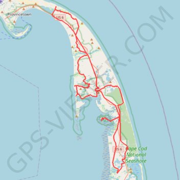
Interactive trail map
Trail profile
- Distance: 97.7 Km
- Elevation gain: 795 m
- Maximum elevation: 36 m
- Elevation loss: 795 m
- Minimum elevation: -4 m
- Moving time: 4 h 7 s
- Moving speed: 24.4 Km/h
- Maximum speed: 53.5 Km/h
- Total time: 4 h 57 m
- Global speed: 19.7 Km/h
About this trail
Name: Cape Cod Fire Roads trail, distance, elevation, map, profile, GPS track
Start: 240, Mill Road, Eastham, Barnstable County, Massachusetts, 02642, United States (41.83324 -69.97757)
End: 205, Mill Road, Eastham, Barnstable County, Massachusetts, 02642, United States (41.83331 -69.97774)
Coordinates: 41.81578 -70.12047 42.06376 -69.96745
Other hiking, mountain biking, running and outdoor activity trails
Click on a trail to view its statistics, map and profile.
GravelBike CapeCod
United States > Massachusetts > Barnstable County > Eastham
Afternoon Ride
Distance: 56.7 Km • Elevation gain: 253 m • Maximum elevation: 19 m
Wandering Eastham
United States > Massachusetts > Barnstable County > Eastham
Distance: 20.2 Km • Elevation gain: 90 m • Maximum elevation: 14 m