Isham Footpath
Evening Run
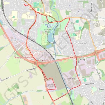
- Distance: 10.2 Km
- Elevation gain: 111 m
- Maximum elevation: 86 m
- Elevation loss: 114 m
- Minimum elevation: 54 m
- Moving time: 59 m 2 s
- Moving speed: 10.4 Km/h
- Maximum speed: 14.5 Km/h
- Total time: 59 m 2 s
- Global speed: 10.4 Km/h
Interactive trail map
Trail profile
- Distance: 10.2 Km
- Elevation gain: 111 m
- Maximum elevation: 86 m
- Elevation loss: 114 m
- Minimum elevation: 54 m
- Moving time: 59 m 2 s
- Moving speed: 10.4 Km/h
- Maximum speed: 14.5 Km/h
- Total time: 59 m 2 s
- Global speed: 10.4 Km/h
About this trail
Name: Isham Footpath trail, distance, elevation, map, profile, GPS track
Coordinates: 52.36022 -0.72062 52.39051 -0.69126
Other hiking, mountain biking, running and outdoor activity trails
Click on a trail to view its statistics, map and profile.
42 Km walk around Wellingborough
United Kingdom > England > North Northamptonshire > Wellingborough > Little Irchester
Distance: 41.7 Km • Elevation gain: 308 m • Maximum elevation: 115 m
The Jo Cox Way 2022 Day 3 Market Bosworth to Milton Keynes
United Kingdom > England > Leicestershire > Hinckley and Bosworth > Market Bosworth
Distance: 122.9 Km • Elevation gain: 953 m • Maximum elevation: 195 m
Kettering Half Marathon
United Kingdom > England > North Northamptonshire > Kettering
Distance: 21.1 Km • Elevation gain: 185 m • Maximum elevation: 110 m