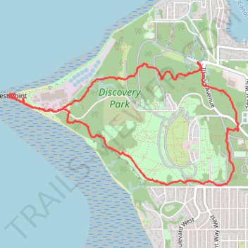
Discovery Park loop hike via West Point Light
- Distance: 7.1 Km
- Elevation gain: 173 m
- Maximum elevation: 103 m
- Elevation loss: 173 m
- Minimum elevation: 0 m
- Moving time: 2 h 55 m
- Moving speed: 2.4 Km/h
- Maximum speed: 36.6 Km/h
- Total time: 3 h 36 m
- Global speed: 2.0 Km/h
Interactive trail map
Trail profile
- Distance: 7.1 Km
- Elevation gain: 173 m
- Maximum elevation: 103 m
- Elevation loss: 173 m
- Minimum elevation: 0 m
- Moving time: 2 h 55 m
- Moving speed: 2.4 Km/h
- Maximum speed: 36.6 Km/h
- Total time: 3 h 36 m
- Global speed: 2.0 Km/h
About this trail
Name: Discovery Park loop hike via West Point Light trail, distance, elevation, map, profile, GPS track
Coordinates: 47.65424 -122.43604 47.66488 -122.40668
Other hiking, mountain biking, running and outdoor activity trails
Click on a trail to view its statistics, map and profile.
Discovery Park trails
United States > Washington > King County > Seattle
Distance: 16.2 Km • Elevation gain: 295 m • Maximum elevation: 109 m