Kaaterskill Falls Trail and Viewing Platform in Kaaterskill Wild Forest
The Kaaterskill Falls Trail offers a scenic journey through the lush forest of the Catskills, leading to breathtaking views of one of New York's tallest waterfalls. Hikers can enjoy multiple vantage points, including a well-maintained viewing platform, where the cascading water plunges dramatically into the rocky basin below, creating a stunning backdrop that is particularly enchanting during the fall foliage season. #Hiking #Waterfall #Forest #Nature
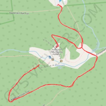
- Distance: 2.6 Km
- Elevation gain: 114 m
- Maximum elevation: 634 m
- Elevation loss: 113 m
- Minimum elevation: 570 m
- Moving time: 46 m 18 s
- Moving speed: 3.4 Km/h
- Maximum speed: 6.4 Km/h
- Total time: 51 m 20 s
- Global speed: 3.1 Km/h
Interactive trail map
Trail profile
- Distance: 2.6 Km
- Elevation gain: 114 m
- Maximum elevation: 634 m
- Elevation loss: 113 m
- Minimum elevation: 570 m
- Moving time: 46 m 18 s
- Moving speed: 3.4 Km/h
- Maximum speed: 6.4 Km/h
- Total time: 51 m 20 s
- Global speed: 3.1 Km/h
About this trail
Name: Kaaterskill Falls Trail and Viewing Platform in Kaaterskill Wild Forest trail, distance, elevation, map, profile, GPS track
Coordinates: 42.19169 -74.06616 42.19567 -74.06130