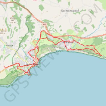
Lyme Regis Charmouth
Dorset National Landscape
- Distance: 23.7 Km
- Elevation gain: 796 m
- Maximum elevation: 174 m
- Elevation loss: 791 m
- Minimum elevation: 0 m
- Moving time: 6 h 5 m
- Moving speed: 3.9 Km/h
- Maximum speed: 29.0 Km/h
- Total time: 6 h 59 m
- Global speed: 3.4 Km/h
Interactive trail map
Trail profile
- Distance: 23.7 Km
- Elevation gain: 796 m
- Maximum elevation: 174 m
- Elevation loss: 791 m
- Minimum elevation: 0 m
- Moving time: 6 h 5 m
- Moving speed: 3.9 Km/h
- Maximum speed: 29.0 Km/h
- Total time: 6 h 59 m
- Global speed: 3.4 Km/h
About this trail
Name: Lyme Regis Charmouth trail, distance, elevation, map, profile, GPS track
Start: Sidmouth Road, Lyme Regis, Dorset, England, DT7 3EU, United Kingdom (50.72543 -2.95014)
End: Gore Lane, Uplyme, East Devon, Devon, England, DT7 3RH, United Kingdom (50.72406 -2.96061)
Coordinates: 50.71888 -2.96061 50.74465 -2.87090
Other hiking, mountain biking, running and outdoor activity trails
Click on a trail to view its statistics, map and profile.
Charmouth to West Bay via Golden Cap, Seatown Beach, Thorncombe Beacon and Eype Beach
United Kingdom > England > Dorset
Distance: 22.8 Km • Elevation gain: 768 m • Maximum elevation: 172 m