Thank you for supporting this site ❤️
Make a donation
Make a donation
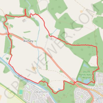
Doune - Buchany
Morning Walk
- Distance: 7.5 Km
- Elevation gain: 137 m
- Maximum elevation: 97 m
- Elevation loss: 137 m
- Minimum elevation: 25 m
- Moving time: 1 h 41 m
- Moving speed: 4.4 Km/h
- Maximum speed: 9.2 Km/h
- Total time: 1 h 41 m
- Global speed: 4.4 Km/h
Interactive trail map
Thank you for supporting this site ❤️
Make a donation
Make a donation
Trail profile
- Distance: 7.5 Km
- Elevation gain: 137 m
- Maximum elevation: 97 m
- Elevation loss: 137 m
- Minimum elevation: 25 m
- Moving time: 1 h 41 m
- Moving speed: 4.4 Km/h
- Maximum speed: 9.2 Km/h
- Total time: 1 h 41 m
- Global speed: 4.4 Km/h
Thank you for supporting this site ❤️
Make a donation
Make a donation
About this trail
Name: Doune - Buchany trail, distance, elevation, map, profile, GPS track
Coordinates: 56.19048 -4.08740 56.20691 -4.05407
Thank you for supporting this site ❤️
Make a donation
Make a donation
Other hiking, mountain biking, running and outdoor activity trails
Click on a trail to view its statistics, map and profile.