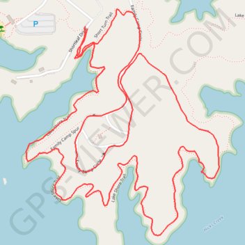
Lake Shore Loop (Lake Norman)
Loop hike along the Lake Norman via Lake Shore Trail, Family Camp Circle and Short Turn Trail in the Lake Norman State Park. #Hiking #Loop #Lake #Nature #Forest
- Distance: 5.8 Km
- Elevation gain: 75 m
- Maximum elevation: 256 m
- Elevation loss: 75 m
- Minimum elevation: 234 m
- Moving time: 1 h 8 m
- Moving speed: 5.1 Km/h
- Maximum speed: 9.8 Km/h
- Total time: 1 h 11 m
- Global speed: 4.9 Km/h
Interactive trail map
Trail profile
- Distance: 5.8 Km
- Elevation gain: 75 m
- Maximum elevation: 256 m
- Elevation loss: 75 m
- Minimum elevation: 234 m
- Moving time: 1 h 8 m
- Moving speed: 5.1 Km/h
- Maximum speed: 9.8 Km/h
- Total time: 1 h 11 m
- Global speed: 4.9 Km/h
About this trail
Name: Lake Shore Loop (Lake Norman) trail, distance, elevation, map, profile, GPS track
Start: Lake Shore Trail, Iredell County, North Carolina, United States (35.64949 -80.94399)
End: Shortleaf Drive, Iredell County, North Carolina, United States (35.64958 -80.94409)
Coordinates: 35.64179 -80.94683 35.65024 -80.93796
Other hiking, mountain biking, running and outdoor activity trails
Click on a trail to view its statistics, map and profile.
Lake Shore Loop Trail in Lake Norman State Park
United States > North Carolina > Iredell County
Distance: 12.4 Km • Elevation gain: 209 m • Maximum elevation: 264 m
Lake Norman State Park Hike
United States > North Carolina > Iredell County
Distance: 5.7 Km • Elevation gain: 67 m • Maximum elevation: 256 m
Lake Shore Loop Trail
United States > North Carolina > Iredell County
Distance: 10.0 Km • Elevation gain: 159 m • Maximum elevation: 264 m
Lake Shore Loop Trail
United States > North Carolina > Iredell County
Distance: 8.9 Km • Elevation gain: 136 m • Maximum elevation: 266 m