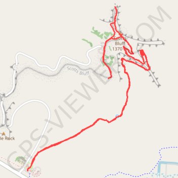
Saddle Rock Trail to Scotts Bluff, North Overlook and South Overlook in Scotts Bluff National Monument
The Saddle Rock Trail offers a captivating hiking experience, showcasing a blend of natural beauty and historical significance. As you traverse the trail, you will encounter remarkable geological formations like Saddle Rock and Eagle Rock, providing striking backdrops for memorable photographs. Along the route, the scenic overlooks reveal expansive views of the North Platte River Valley and the surrounding prairie, making this hike a rewarding adventure for nature enthusiasts and history buffs alike. #Hiking #Rock #Nature #Overlook
- Distance: 6.6 Km
- Elevation gain: 307 m
- Maximum elevation: 1,414 m
- Elevation loss: 306 m
- Minimum elevation: 1,251 m
- Moving time: 1 h 25 m
- Moving speed: 4.6 Km/h
- Maximum speed: 7.0 Km/h
- Total time: 1 h 29 m
- Global speed: 4.4 Km/h
Interactive trail map
Trail profile
- Distance: 6.6 Km
- Elevation gain: 307 m
- Maximum elevation: 1,414 m
- Elevation loss: 306 m
- Minimum elevation: 1,251 m
- Moving time: 1 h 25 m
- Moving speed: 4.6 Km/h
- Maximum speed: 7.0 Km/h
- Total time: 1 h 29 m
- Global speed: 4.4 Km/h
About this trail
Name: Saddle Rock Trail to Scotts Bluff, North Overlook and South Overlook in Scotts Bluff National Monument trail, distance, elevation, map, profile, GPS track
Start: Saddle Rock Trail, Scotts Bluff County, Nebraska, 69341, United States (41.82865 -103.70710)
End: Oregon Trail, Scotts Bluff County, Nebraska, 69341, United States (41.82827 -103.70742)
Coordinates: 41.82827 -103.70743 41.83997 -103.69574