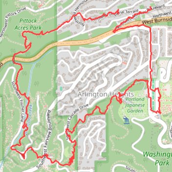
Loop hike via Pittock Acres Park, Wilwood Trail, Hoyt Arboretum, Magnolia Trail, Washington Park and Japanes Garden Trail
- Distance: 6.6 Km
- Elevation gain: 188 m
- Maximum elevation: 250 m
- Elevation loss: 197 m
- Minimum elevation: 133 m
- Moving time: 1 h 39 m
- Moving speed: 4.0 Km/h
- Maximum speed: 18.3 Km/h
- Total time: 1 h 45 m
- Global speed: 3.8 Km/h
Interactive trail map
Trail profile
- Distance: 6.6 Km
- Elevation gain: 188 m
- Maximum elevation: 250 m
- Elevation loss: 197 m
- Minimum elevation: 133 m
- Moving time: 1 h 39 m
- Moving speed: 4.0 Km/h
- Maximum speed: 18.3 Km/h
- Total time: 1 h 45 m
- Global speed: 3.8 Km/h
About this trail
Name: Loop hike via Pittock Acres Park, Wilwood Trail, Hoyt Arboretum, Magnolia Trail, Washington Park and Japanes Garden Trail trail, distance, elevation, map, profile, GPS track
Coordinates: 45.51507 -122.71898 45.52488 -122.70581
Other hiking, mountain biking, running and outdoor activity trails
Click on a trail to view its statistics, map and profile.
Great Northwest Loop in Washington Park
United States > Oregon > Multnomah County > Portland
The Great Northwest Loop offers a pleasant and scenic escape with a variety of highlights. As you hike, you'll pass through lush forests filled with tall trees, including Douglas-firs and maples, along well-maintained paths that lead to stunning vistas. The route also connects several renowned park…
Distance: 7.2 Km • Elevation gain: 239 m • Maximum elevation: 268 m
The Watcher in the Water
United States > Oregon > Multnomah County > Portland
Distance: 82.9 Km • Elevation gain: 1,451 m • Maximum elevation: 300 m