William S. Hart Park
- Distance: 1.5 Km
- Elevation gain: 44 m
- Maximum elevation: 434 m
- Elevation loss: 44 m
- Minimum elevation: 393 m
- Moving time: 27 m 11 s
- Moving speed: 3.3 Km/h
- Maximum speed: 5.9 Km/h
- Total time: 34 m 47 s
- Global speed: 2.6 Km/h
Interactive trail map
Trail profile
- Distance: 1.5 Km
- Elevation gain: 44 m
- Maximum elevation: 434 m
- Elevation loss: 44 m
- Minimum elevation: 393 m
- Moving time: 27 m 11 s
- Moving speed: 3.3 Km/h
- Maximum speed: 5.9 Km/h
- Total time: 34 m 47 s
- Global speed: 2.6 Km/h
About this trail
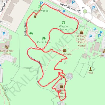
Name: William S. Hart Park trail, distance, elevation, map, profile, GPS track
Coordinates: 34.37356 -118.52864 34.37682 -118.52652
Other hiking, mountain biking, running and outdoor activity trails
Click on a trail to view its statistics, map and profile.
William S. Hart Park Trails
United States > California > Los Angeles County > Santa Clarita
Distance: 4.8 Km • Elevation gain: 163 m • Maximum elevation: 479 m