Walker Ranch Loop Trail in Walker Ranch Park
The Walker Ranch Loop Trail near Boulder, Colorado, offers hikers a diverse journey through lush forests, open meadows, and along the South Boulder Creek. Along the path, you'll encounter historic remnants of old homesteads, providing a glimpse into the area's past. The trail also features impressive rock formations and panoramic views of the surrounding mountain ranges, including Flatirons and Indian Peaks, making it a favorite among local outdoor enthusiasts. #Hiking #Mountain #Forest #Nature #Overlook
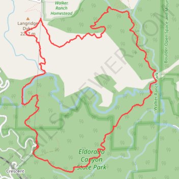
- Distance: 12.2 Km
- Elevation gain: 510 m
- Maximum elevation: 2,239 m
- Elevation loss: 509 m
- Minimum elevation: 1,969 m
- Moving time: 1 h 35 m
- Moving speed: 7.7 Km/h
- Maximum speed: 41.8 Km/h
- Total time: 1 h 42 m
- Global speed: 7.2 Km/h
Interactive trail map
Trail profile
- Distance: 12.2 Km
- Elevation gain: 510 m
- Maximum elevation: 2,239 m
- Elevation loss: 509 m
- Minimum elevation: 1,969 m
- Moving time: 1 h 35 m
- Moving speed: 7.7 Km/h
- Maximum speed: 41.8 Km/h
- Total time: 1 h 42 m
- Global speed: 7.2 Km/h
About this trail
Name: Walker Ranch Loop Trail in Walker Ranch Park trail, distance, elevation, map, profile, GPS track
Coordinates: 39.92811 -105.34141 39.95310 -105.31483
Other hiking, mountain biking, running and outdoor activity trails
Click on a trail to view its statistics, map and profile.
Eldorado Canyon Trail
United States > Colorado > Boulder County
The Eldorado Canyon Trail in Colorado offers hikers a rewarding journey through diverse terrains, beginning with a steep ascent that provides panoramic views of the canyon's towering rock formations, often dotted with climbers. As the trail progresses, it winds through shaded forests, leading to a ridge that…
Distance: 10.7 Km • Elevation gain: 652 m • Maximum elevation: 2,167 m