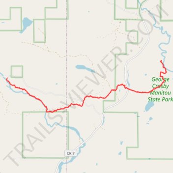
USA MN SHT - Sonju Lake Road Trailhead to Manitou State Park
- Distance: 8.6 Km
- Elevation gain: 140 m
- Maximum elevation: 474 m
- Elevation loss: 180 m
- Minimum elevation: 403 m
- Moving time: 2 h 45 m
- Moving speed: 3.1 Km/h
- Maximum speed: 5.1 Km/h
- Total time: 3 h 17 s
- Global speed: 2.9 Km/h
Interactive trail map
Trail profile
- Distance: 8.6 Km
- Elevation gain: 140 m
- Maximum elevation: 474 m
- Elevation loss: 180 m
- Minimum elevation: 403 m
- Moving time: 2 h 45 m
- Moving speed: 3.1 Km/h
- Maximum speed: 5.1 Km/h
- Total time: 3 h 17 s
- Global speed: 2.9 Km/h
About this trail
Name: USA MN SHT - Sonju Lake Road Trailhead to Manitou State Park trail, distance, elevation, map, profile, GPS track
Coordinates: 47.47219 -91.17872 47.48828 -91.10541
Other hiking, mountain biking, running and outdoor activity trails
Click on a trail to view its statistics, map and profile.
USA MN SHT - Manitou State Park to Crystal Creek Campsite
United States > Minnesota > Lake County > Lake No. 1
Distance: 13.2 Km • Elevation gain: 326 m • Maximum elevation: 491 m