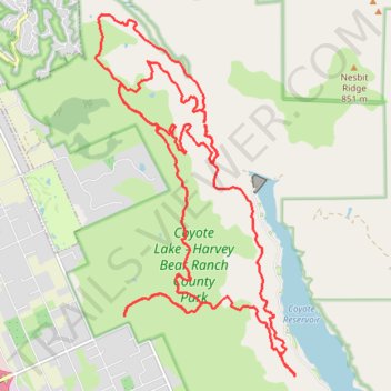
Coyote Lake - Harvey Bear Ranch County Park MTB Ride
- Distance: 30.1 Km
- Elevation gain: 877 m
- Maximum elevation: 446 m
- Elevation loss: 877 m
- Minimum elevation: 108 m
- Moving time: 2 h 39 m
- Moving speed: 11.3 Km/h
- Maximum speed: 51.5 Km/h
- Total time: 3 h 18 m
- Global speed: 9.1 Km/h
Interactive trail map
Trail profile
- Distance: 30.1 Km
- Elevation gain: 877 m
- Maximum elevation: 446 m
- Elevation loss: 877 m
- Minimum elevation: 108 m
- Moving time: 2 h 39 m
- Moving speed: 11.3 Km/h
- Maximum speed: 51.5 Km/h
- Total time: 3 h 18 m
- Global speed: 9.1 Km/h
About this trail
Name: Coyote Lake - Harvey Bear Ranch County Park MTB Ride trail, distance, elevation, map, profile, GPS track
Start: Martin Murphy Trail, Santa Clara County, California, 94046, United States (37.09861 -121.57568)
End: Martin Murphy Trail, Santa Clara County, California, 94046, United States (37.09853 -121.57565)
Coordinates: 37.08937 -121.58123 37.14412 -121.54328