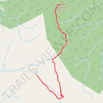
Raspberry Mountain Trail
- Distance: 9.6 Km
- Elevation gain: 327 m
- Maximum elevation: 3,204 m
- Elevation loss: 332 m
- Minimum elevation: 2,954 m
- Moving time: 2 h 44 m
- Moving speed: 3.5 Km/h
- Maximum speed: 15.6 Km/h
- Total time: 3 h 58 m
- Global speed: 2.4 Km/h
Interactive trail map
Trail profile
- Distance: 9.6 Km
- Elevation gain: 327 m
- Maximum elevation: 3,204 m
- Elevation loss: 332 m
- Minimum elevation: 2,954 m
- Moving time: 2 h 44 m
- Moving speed: 3.5 Km/h
- Maximum speed: 15.6 Km/h
- Total time: 3 h 58 m
- Global speed: 2.4 Km/h
About this trail
Name: Raspberry Mountain Trail trail, distance, elevation, map, profile, GPS track
Start: 762, FS 383, Teller County, Colorado, 80814, United States (38.88670 -105.13253)
End: 757, FS 383, Teller County, Colorado, 80814, United States (38.88714 -105.13310)
Coordinates: 38.88056 -105.13310 38.90636 -105.12243