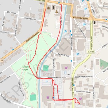
Kilmarnock, Scotland
Afternoon Walk
- Distance: 2.0 Km
- Elevation gain: 7 m
- Maximum elevation: 35 m
- Elevation loss: 10 m
- Minimum elevation: 25 m
- Moving time: 20 m 56 s
- Moving speed: 5.8 Km/h
- Maximum speed: 8.0 Km/h
- Total time: 47 m 3 s
- Global speed: 2.6 Km/h
Interactive trail map
Trail profile
- Distance: 2.0 Km
- Elevation gain: 7 m
- Maximum elevation: 35 m
- Elevation loss: 10 m
- Minimum elevation: 25 m
- Moving time: 20 m 56 s
- Moving speed: 5.8 Km/h
- Maximum speed: 8.0 Km/h
- Total time: 47 m 3 s
- Global speed: 2.6 Km/h
About this trail
Name: Kilmarnock, Scotland trail, distance, elevation, map, profile, GPS track
Coordinates: 55.60139 -4.50184 55.60751 -4.49625
Other hiking, mountain biking, running and outdoor activity trails
Click on a trail to view its statistics, map and profile.
Irvine, Scotland to Stonehouse and back
United Kingdom > Scotland > North Ayrshire > Irvine
Stonehouse, South Lanarkshire, Bike, Loop
Distance: 111.8 Km • Elevation gain: 1,118 m • Maximum elevation: 302 m
Irvine, Scotland to Kilmarnock and back
United Kingdom > Scotland > North Ayrshire > Irvine
Bike
Distance: 32.1 Km • Elevation gain: 192 m • Maximum elevation: 66 m
Irvine, Scotland to Kilmarnock and back
United Kingdom > Scotland > North Ayrshire > Irvine
Afternoon Bike Ride
Distance: 34.2 Km • Elevation gain: 217 m • Maximum elevation: 91 m
Irvine, Scotland to Kilmarnock and back
United Kingdom > Scotland > North Ayrshire > Irvine
Evening Bike Ride
Distance: 42.0 Km • Elevation gain: 259 m • Maximum elevation: 92 m
Irvine, Scotland to Kilmarnock and back
United Kingdom > Scotland > North Ayrshire > Irvine
Morning Bike Ride
Distance: 27.2 Km • Elevation gain: 147 m • Maximum elevation: 57 m